Climate & Conflict

Climate & Conflict

What is the relation between
climate change
and
violent conflicts
? Which role do socio-economic
scope conditions
play in exacerbating climate impact? How can we allow analysts and policymaker to make better decisions — based on heterogenous, multi-faceted information sources?

Regions in Focus

Which regions are most affected?

This section shows a global overview of a selected set of hotspot regions, which are currently strongly affected by

climate change
, being especially vulnerable from unfavorable socio-economic
scope conditions
, and/or suffering from ongoing
conflicts
.

In this map, worldwide scores in each of these three topics were calculated on a one-degree latitude-longitude grid.

Click/tap a region to reveal detailed scores. Or, choose one of the three factors at the bottom of the map, in order to view them in isolation.

The data for this map combines different information sources and levels of analysis:
  • The grid scores for the three dimensions (Climate Impact, Scope Conditions and Conflict) were developed in cooperation with the Center for Crisis Early Warning. They combine publicly available data sources such as ACLED, the World Bank and V-Dem with a custom analysis provided by Verisk Maplecroft.
  • The hotspot shapes and labels were defined based on existing analysis in the context of the Climate Diplomacy project.
  • The hotspot scores present an aggregation of the grid scores for the contained area. Here, scores were normalized across dimensions, so that the three dimensions are presented with comparable overall value distributions across hotspots.
Find more details in our technical documentation.

Concept Framework

What does the analysis take into account?

Climate change
is “a change of climate which is attributed directly or indirectly to human activity that alters the composition of the global atmosphere and which is in addition to natural climate variability observed over comparable time periods”. It has already led to an increased rate and severity of climate-related hazards such as weather extremes and natural disasters, with serious adverse effects on human systems. This disproportionally affects the most vulnerable communities and countries, who are already less able to adapt to changing climatic conditions.

Negative causal relationships between climate and conflict become more likely when certain

scope conditions
are present: Societies with low adaptive capacity to the effects of climate change due to economic factors, political factors, or high dependence on renewable natural resources are more likely to experience adverse effects of climate on conflict. Detrimental effects of conflicts on development, economy and governance may in turn reduce the adaptive capacity and resilience to climate change hazards, increasing vulnerability.

Violent conflicts
range from low-intensity, localized conflicts with only occasional occurrences of violence to full-blown civil wars with international involvement. While each violent conflict takes place in a unique context, several characteristics of societies are generally associated with higher risks of conflict.

What is the relation between these factors?

The interplay between climate and conflict has received increasing attention from researchers and policymakers over the last two decades. There is significant overlap between countries most affected by climate change and those most at risk of violent conflict. Evidence for adverse effects of climate factors on conflict exists predominantly for internal conflict. Despite this, climate factors are currently thought to play only a minor role as a direct cause or trigger of conflict compared to other risk factors. However, they can influence conflicts indirectly by impacting those factors, for example by exacerbate existing tensions and grievances and lowering the opportunity costs of conflict. In doing so, climate factors may affect the duration and intensity of existing conflicts stronger than the risk of conflict onset. Climate change in the context of conflict is therefore considered a potential “threat multiplier” first and foremost.

Case study

Farmer herder conflict

Nigeria

6.4
6.6
7.7

What can we learn from looking at the ongoing conflicts in Nigeria?

Nigeria is an example of a country with high conflict intensity, which is frequently discussed within a climate narrative. With a high dependency on agriculture, preexisting tensions between different ethnic groups and high levels of state fragility, several scope conditions for adverse climate-conflict effects are present.

This case study explores the history of conflict, the changes in climate patterns and the socio-economic situation in Nigeria. It highlights how multiple pressures acting within the country can lead to heightened societal and economic tensions and potentially contribute to the persisting violence.

After years of lower numbers of incidents in the early 2000s, the intensity of violent conflict in Nigeria has been consistently high over the last decade. While it is difficult to directly attribute instances of violence to specific climatic or socio-economic developments, it is possible to identify trends in the state of ecosystems and population that help to explain their likelihood.

Since 2000, across the Sahel region almost 60.000 conflict events were recorded in ACLED, with a total of roughly 300.000 fatalities. While conflict is relatively high across the whole region, the distribution is not homogenous. Nigeria was the country most affected by conflict, both in terms of events and fatalities. While multiple different conflicts are taking place in Nigeria at the same time, in this context we will be focusing on conflicts in
Nigeria's middle belt
, which are characterized by confrontations between sedentary farmers and nomadic herders.

One of the most defining factors for determining how sensitive a region is to a deteriorating climate conditions and ecosystems is the direct dependency of people on agriculture for income or subsistence. If the climate changes, food security and food prices will be directly affected. Employment in agriculture has been steadily dropping in Nigeria from 80% in 1960 to around 40% in 1980 but saw this reversed after that.

In the Sahel region land use can be broadly divided into nomadic herding and sedentary farming. While the former depends on naturally growing
grassland
, the latter actively transforms land into
crop land
. Both however require intact ecosystems that can sustain healthy and fertile soil, a resource which is in an increasingly perilous state.

Traditionally, both herders and farmers coexisted mostly peacefully alongside each other. Recent developments like diversification in agriculture, changing crop cycles as well as questions around land ownership have since contributed to tensions between them.
Rising temperatures cause water to evaporate faster. This leads to
increasingly drier soil
, especially central in northern Nigeria.

The SPEI (Standardised Precipitation-Evapotranspiration Index) measures the water balance based on rainfall and evapotranspiration. While the year-to-year fluctuation is big, the loss of water through evaporation and transpiration clearly outweighed the gain of water through precipitation over the last two decades. This increases the pressure on natural ecosystems as well as agricultural activities.
The decrease in water availability in turn increases the risk of land degradation and lower crop yield or crop loss, making life harder for communities dependent on agriculture.

The
NDVI
(Normalized difference vegetation index) is a measure for the health of vegetation. In the last two decades plant health has gotten
increasingly worse
in the majority of grassland and cropland.

While the state of ecosystems and soil are in an increasingly precarious state, they have to yield food for a growing population. Over the last two decades the

population of Nigeria grew
by almost
70%
.

By moving to more industrialised farming practices and expanding croplands Nigeria managed to increase agricultural output in the short term. However, the growth in agricultural production is not able to keep pace with the growth in population. This can be seen best when looking at the
share of undernourished people
which grew by 3% since 2000.
The pressures through climate factors alone do not cause violent conflicts. A number of different factors play a role as well. The “Fragile States Index” combines indicators on the social, political, and economic status as well as societal cohesion within a given country in order to assess its stability. Looking at
the overall index
, Nigeria is consistently ranked highly fragile. Additionally, Nigeria has gained 10 places (with more fragile countries higher on the list) in the global ranking since 2006. Looking at
individual subindicators
, we can see how they may have contributed to conflicts.
One major driver of conflicts is the cohesion of the social fabric or lack thereof. How big are divides between different ethnic, religious, tribal etc. groups. The
“Fractionalized Elites”
indicator sheds light on fragmentation along group identities in the political and institutional sphere while
“Group Grievance”
looks at the distribution of resources and services of said groups while also considering a historical angle. In Nigeria both indicators are exceptionally high.
The
state of the economy
plays a role in a country’s resilience to negative pressures. In Nigeria, increasing economic decline can be observed, based on factors such as per capita income, GDP, inflation, business climate, or economic diversity. Additionally,
economic inequality
was exceptionally high when the frequency of conflict events in Nigeria started to increase around 2010, with many well-educated people leaving the country. However, positive trends towards lower inequality and reduced
brain drain
in recent years may be a reason for hope.
The increase in agricultural production is clearly visible when looking at the change in land use over the past two decades. While there has been some
reduction
in crop land in the south, throughout the central region agricultural activities have greatly
intensified
.
At the same time the area of grassland, providing grazing grounds for nomadic herders, has
decreased
. Some
additional area
was gained through the temporary retreat of the Sahel but overall, the area decreased.
Deterioration of ecosystems through changing weather patterns as well as intensification of farming activities to create food for a growing population puts a lot of pressure on people directly depending on agriculture for survival. Combined with changes in land use patterns from those established over centuries, this contributes to intensified tensions between sedentary agricultural and nomadic people. Increasingly, these tensions result in violence between the different groups involved, such as the
Fulani herders
.

What's next

We will continue to investigate the relationship between climate and conflict in more detail in a multi-disciplinary research project as well as further communication outputs and dialogue formats.

In particular, we are currently investigating dynamic, data-driven hotspot detection as well as temporal trends.

Let us know in case you would like to be notified of any future activities and results in that space.
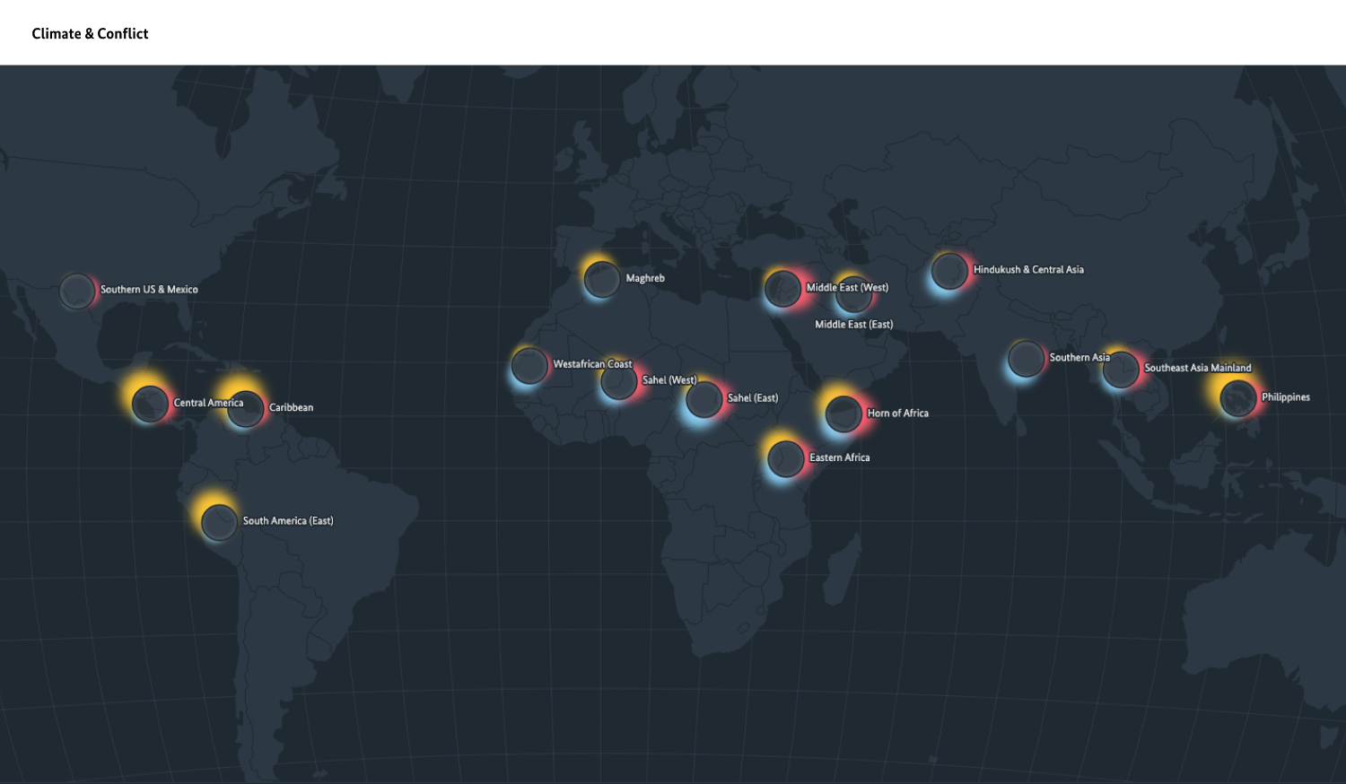
Mockup for a future data explorer

Technical Notes

Find more information on the data sources and processing behind this site in our technical notes.

Site news and change log

  • 2023-03-01   |   Update conflict data & improved accessibility
  • 2022-10-17   |   Official Launch